 FAO Map Catalog
FAO-UN - AGLL (ex-FAO Land and Water Division)
Type of resources
Available actions
Topics
Keywords
Contact for the resource
Provided by
Years
Formats
Representation types
Update frequencies
status
Scale
-

Recommended input level (for maize) for sub-saharean Africa based on the FAO-UNESCO Soil Map of the World.
-

The compilation of a Soil and Terrain digital database for the South-African region forms a part of the ongoing activities of the Food and Agriculture Organisation of the United Nations (FAO) and the International Soil Reference and Information Centre (ISRIC) to update the world?s baseline information on natural resources. The updating of world soil resources, using the Soil and Terrain (SOTER) digital database methodology, is part of a global SOTER programme and intended to replace the FAO/Unesco 1:5 million scale Soil Map of the World (1971-1981). The African sheet of this map was published in 1973 and has been compiled on basis of information and data available at that time. It is understandable that a substantial part does not reflect the present state of knowledge of the soils in that region. The national institutes, responsible for the natural resources inventories, have been collecting a wealth of new information on the distribution and occurrence of soils in their region, which has resulted in updating their national soil maps mostly at scale 1:1 million, often applying the Revised Legend (FAO, UNEP, ISRIC, 1988) for the description of the mapping units. The International Union of Soil Science (IUSS) adopted an important change in the classification used for the map by introducing lower levels of subunits of the World Reference Base for Soil Resources (IUSS, FAO, ISRIC, 1998). This, together with the new soil data available at national level, justified such an update of the soil resources for the Southern African region. The compilation of a Soil and Terrain digital database for the South-African region forms a part of the ongoing activities of the Food and Agriculture Organisation of the United Nations (FAO) and the International Soil Reference and Information Centre (ISRIC) to update the world?s baseline information on natural resources. The updating of world soil resources, using the Soil and Terrain (SOTER) digital database methodology, is part of a global SOTER programme and intended to replace the FAO/Unesco 1:5 million scale Soil Map of the World (1971-1981). The African sheet of this map was published in 1973 and has been compiled on basis of information and data available at that time. It is understandable that a substantial part does not reflect the present state of knowledge of the soils in that region. The national institutes, responsible for the natural resources inventories, have been collecting a wealth of new information on the distribution and occurrence of soils in their region, which has resulted in updating their national soil maps mostly at scale 1:1 million, often applying the Revised Legend (FAO, UNEP, ISRIC, 1988) for the description of the mapping units. The International Union of Soil Science (IUSS) adopted an important change in the classification used for the map by introducing lower levels of subunits of the World Reference Base for Soil Resources (IUSS, FAO, ISRIC, 1998). This, together with the new soil data available at national level, justified such an update of the soil resources for the Southern African region.
-

Map showing 35 lengths of growing period zones for the developing world. Digital version of "Major Climatic Divisions" derived from the Agro-Ecological Zones Project, made by FAO in 1978. Refer to World Soil Resources Report 48, Vol. 1 Methodology and Results for Africa; Vol. 2 Results for Southwest Asia; Vol. 3 Methodology and Results for South and Central America; Vol. 4 results for Near East.
-
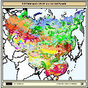
The digital soil map for North and Central Eurasia region (covering China, Taiwan Province of China, Mongolia, CIS and the Baltic States) was prepared by FAO and IIASA in co-operation with: ? the Institute of Soil Science, Academia Sinica (Li Jin, Zhou House in 1978) for China and Taiwan Province of China (scale 1:4 million). ? the Pocveni Institute, V. Stolbovoy and B. Sheremet (1994) for Mongolia (scale 1:2.5 million) The original soil maps from China, Mongolia and CIS_BS have been merged by introducing DCW boundaries between: China-CIS_BS; China-Mongolia; Mongolia-CIS_BS. The original soil map of China includes the Chinese line between India and China, which extends beyond the Indian line, and the South China Sea islands (no soil information is present for the South China Sea islands). Those boundaries do not imply the expression of any opinion whatsoever on the part of FAO concerning the legal or constitutional states of any country, territory, or sea area, or concerning delimitation of frontiers. For further information on related tables, texture etc. please read the readme.rtf and readme.xls documents available for downloading.
-
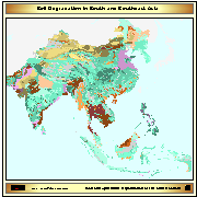
ASSOD (1997) is a follow-up activity of GLASOD. The same methodology was used at a more detailed scale (1:5M) for South and Southeast Asia. The GLASOD methodology was slightly refined. © ISRIC,FAO,UNEP, 1997
-

Beta version of a thematic grid of Land Use Systems (LUS) and its attributes for Sub-Saharan Africa with a spatial resolution of 5 arc minutes or 0.083333 decimal degrees. This dataset, presented as beta version, is developed in the framework of the LADA project (Land degradation Assessment in Drylands) by the Land Tenure and Management Unit of the Food and Agriculture Organization of the United Nations and is copyright of FAO/UNEP GEF. The LUS map implementation is based on a innovative methodology combining more than 10 global datasets. Due to the map generation method, the quality of the map can never be uniform. The overall quality of the map depends heavily on the individual quality of the data for the different countries.
-
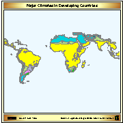
Map showing 16 major climate classes for the Developing World. Digital version of "Major Climatic Divisions" derived from the Agro-Ecological Zones Project, made by FAO in 1978. Refer to World Soil Resources Report 48, Vol. 1 Methodology and Results for Africa; Vol. 2 Results for Southwest Asia; Vol. 3 Methodology and Results for South and Central America; Vol. 4 results for Near East.
-

Dryland map derived from the Aridity index map (P/PET).
-
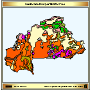
Dominant soil map of Burkina Faso derived from the Digital Soil Map of the World.
-
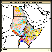
The SEA (Soil and Terrain Database Map of East Africa) is a Digital Soil Map at 1:1000000 scale for the following countries: Burundi, Djibouti, Egypt, Eritrea, Ethiopia, Kenya, Somalia, Sudan, Rwanda, and Uganda. Compilation of the SEA was subcontracted to ISRIC (Netherlands) by FAO in 1988. The main purpose, at that time, was to test the validity of the 1988 revision of the FAO/Unesco legend for the Soil Map of the World at 1:1 million scale. In 1990, the maps and the related tabular databases were automated (converted into digital form), in the FAO Geographic Information System Centre. The final version as been completed and made available in CD-ROM since 1998.